
Junction City ZIP Coverage
Official USPS pages support two relevant five-digit ZIP codes in the immediate search area. The key difference is the postal-city label. ZIP 66441 is the primary Junction City mailing ZIP, while 66442 belongs to the Fort Riley postal city and installation. USPS did not publish a neighborhood-by-neighborhood boundary list in the inspected pages, so the safe descriptions are postal areas rather than claims about every subdivision or street.
| ZIP | Area label | Official post office | Research note |
|---|---|---|---|
| 66441 | Junction City postal area | Junction City Post Office, 302 W 7th Street | Primary city mailing ZIP; check parcel situs and limits separately |
| 66442 | Fort Riley installation and postal area | Fort Riley Post Office, 5302 Morelock Street | Separate postal city and jurisdiction; not proof of a Junction City address |
No added five-digit ZIP for the Junction City city label, PO-box-only ZIP, unique institutional ZIP, or dated ZIP split was verified. ZIP+4 and carrier routes are address-specific. This ZIP code directory therefore does not invent neighborhood borders or population counts that USPS did not publish.
Junction City 66441 Mail Core
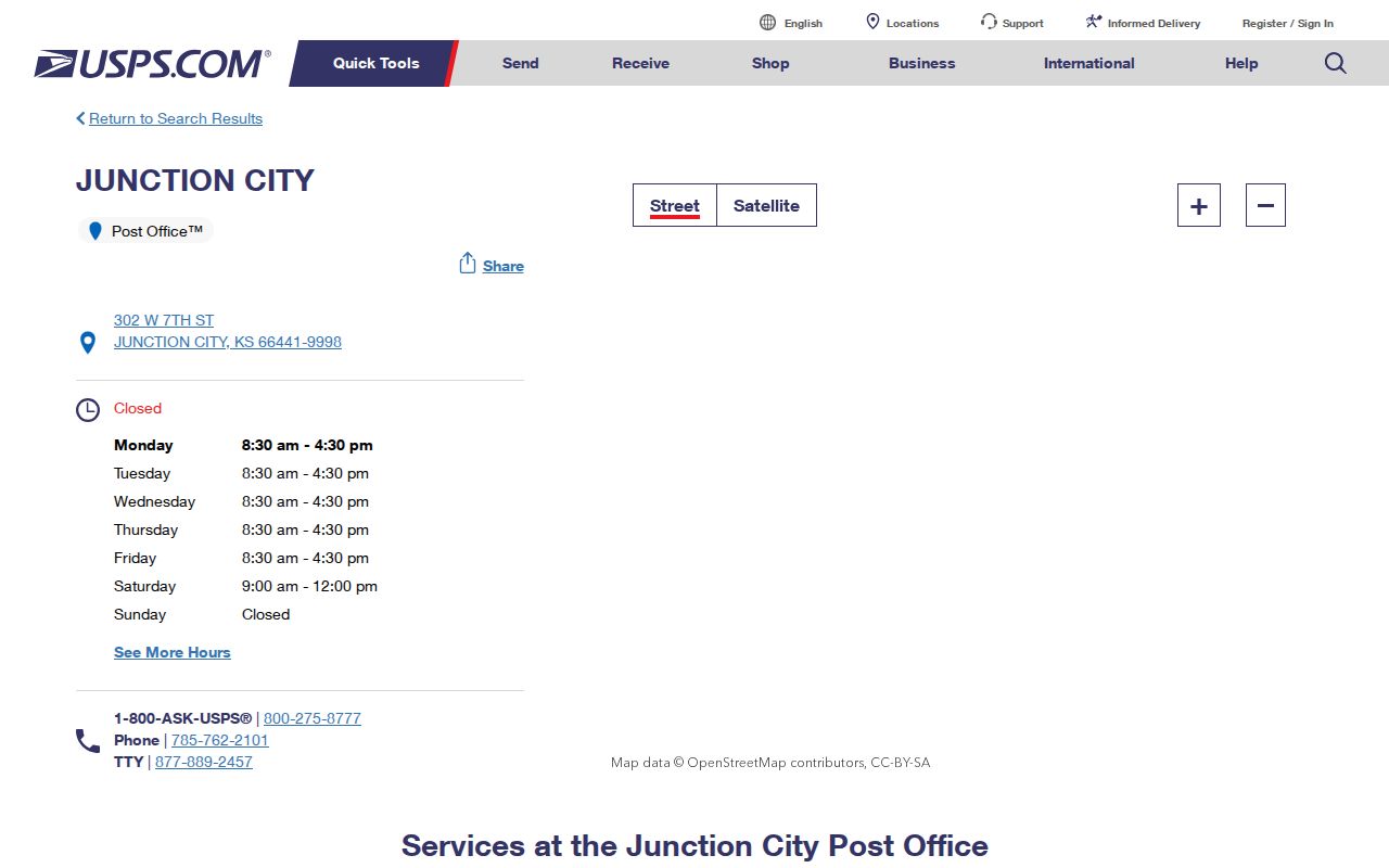
The Junction City Post Office is listed at 302 W 7th Street, Junction City, KS 66441-9998, with phone 785-762-2101. Posted retail hours are Monday through Friday, 8:30 a.m. to 4:30 p.m., and Saturday, 9 a.m. to noon. PO box access is posted as 24 hours. Check the live USPS page before a visit because operating details can change.
The official USPS location page for Junction City documents the main postal facility.
For mail, use the post office listing and the address lookup. For property, taxes, permits, voting, or municipal services, switch to the agency that controls that record. A Junction City mailing line may serve land outside the incorporated boundary.
Fort Riley ZIP 66442 Context
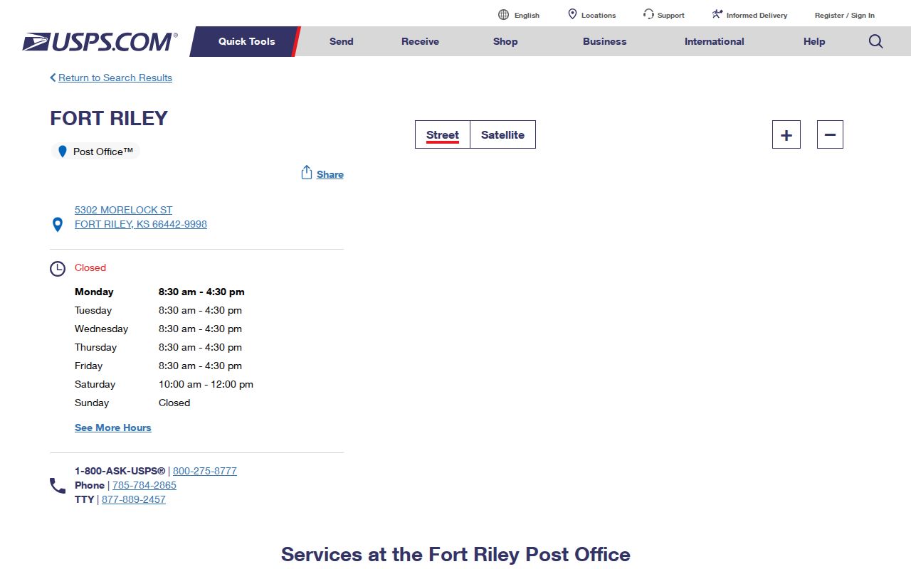
The Fort Riley Post Office is listed at 5302 Morelock Street, Fort Riley, KS 66442-9998, with phone 785-784-2865. Posted retail hours are Monday through Friday, 8:30 a.m. to 4:30 p.m., and Saturday, 10 a.m. to noon. This is the adjacent installation's postal city, not a second Junction City municipal ZIP.
The official Fort Riley USPS page makes the separate postal label visible.
Fort Riley is the main geography trap in a Junction City ZIP code directory. City, county, postal, and federal or military custodians may all appear in one regional search. Do not infer military status from a mailing address. Keep the postal city, municipal limits, installation, and land-record keeper as separate facts.
Standardize a Junction City ZIP
The USPS ZIP Lookup Tool has three useful paths. By Address accepts an optional company, required street address, optional apartment or suite, required city and state, and optional ZIP. By City and State returns postal-city ZIP information. Cities by ZIP reverses a known five-digit code to its accepted city labels. USPS warns that a result does not confirm a person or company at the address.
| USPS mode | Inputs | Best use |
|---|---|---|
| By Address | Street, unit, city, state, optional ZIP | Get the current standardized line and address-specific ZIP+4 |
| By City and State | City and state | Check the accepted five-digit postal area |
| Cities by ZIP | Five-digit ZIP | See the postal-city naming tied to the code |
A standardized result is the sound first step because spelling, unit form, and postal city can affect later searches. Keep the returned ZIP+4 with the date checked. Postal standards and local record systems can change on different schedules.
Find Junction City Residents by ZIP
No inspected local portal offered a reliable public ZIP-wide resident roster. ATCi has City and Property Situs Address fields, but no visible ZIP filter. VoterView uses a registrant's first name, last name, and date of birth, or a residential-address autocomplete for polling-place search. SmartGov's basic parcel screen accepts parcel number, address, or owner name. A lawful statewide voter-file request is controlled, paid, and restricted, not a tool for publishing a neighborhood list.
- Enter the full street address in USPS By Address and save the standardized city, state, ZIP, and ZIP+4.
- Search Geary County ATCi by situs address and the portal's exact City value. Save the parcel ID and legal description.
- Check the county GIS viewer and Junction City numbering rules when the parcel or boundary is unclear. GIS is a planning aid, not a legal survey.
- Use the dedicated court, voter, or historical source only if that record answers the purpose. Keep each result's date and limits.
- Once a code narrows the area, use the Junction City street directory for the address-level process.
A ZIP code directory narrows mail geography. It does not establish current occupancy. Search one parcel or person at a time and verify the needed fact with its custodian.
Junction City Portal Spelling Trap
The ATCi City selector contains Junction City, the typo Junction Ctiy, plus both Fort Riley and FT RILEY. This is more than a comic data quirk. A no-result search may come from the stored city value rather than a missing parcel. Test the visible options before concluding that an address is absent.
ATCi exposes many other narrowing fields: Parcel ID, Quick Ref, COV number, owner name, property situs address, tax unit, subdivision, block, lot, section, township, range, neighborhood code, size, year, valuation, and sale ranges. None should be described as a ZIP filter. The public card may show both situs and owner mailing fields, and those two addresses can have different city or ZIP labels.
Portal tip. Search every exact Junction City and Fort Riley label shown in ATCi before treating a zero-result screen as final.
Junction City ZIP Versus Limits
ZIP codes are USPS delivery constructs. Junction City boundaries are municipal geography. Parcel situs is the physical address used by the assessor, while an owner's mailing address is where notices are sent. Those labels often agree, but agreement is not guaranteed. A 66441 mailing address can serve a county pocket, and 66442 points to Fort Riley postal context without proving the relevant land or record custodian.
- ZIP code
- A five-digit USPS delivery code tied to postal routing, not a city boundary.
- ZIP+4
- An address-specific four-digit extension that narrows delivery beyond the five-digit code.
- PO-box ZIP
- A code reserved chiefly for post-office boxes. None was verified for Junction City in this research.
- Unique ZIP
- A code assigned to one high-volume organization. None was verified here.
- Carrier route
- A group of delivery points served in a postal route, not a resident roll.
Within Junction City, the property-numbering system begins from First and Washington and sets odd and even sides by direction. County GIS/Planning/Zoning handles county mapping questions. No official comprehensive annexation, readdressing, or ZIP realignment timeline was located, so a date-specific dispute should be checked in ordinances, plats, GIS material, and newspaper notices.
Date Junction City Address Clues
ZIP codes are modern clues and cannot be projected into the city's earliest records. Junction City used earlier place names including Manhattan, Millard City, and Humboldt before its present name in 1857. Geary County was Davis County until 1889. A historical search may therefore require a prior county name, old street form, and the source's own date rather than a present ZIP.
For a past address, compare a dated newspaper or directory entry with census street indexes, Sanborn maps, and the current parcel card. The 1912 Sanborn sheets show building footprints and street context, while current GIS shows parcel geometry. Neither is an occupant list. Dorothy Bramlage Library and Geary Historical Society can help with exact names, dates, and addresses when no reverse directory is online.
What Junction City ZIPs Prove
A USPS result proves how the Postal Service standardizes the submitted address at the time checked. It does not prove ownership, occupancy, city taxes, school assignment, voting eligibility, or access to municipal services. The assessor card is also limited: it reports the assessor's parcel fields, not a complete title or a live household list. VoterView and court tools each have separate identity and privacy controls.
Record only the fact supported by the source. Use “USPS postal city,” “parcel situs,” “owner mailing field,” and “municipal boundary” as distinct labels. That discipline prevents the common error of turning one Junction City ZIP code into a claim about a person or jurisdiction. When sources conflict, contact USPS for mail, Geary County for parcels, Junction City for city boundaries and numbering, or the proper federal custodian for Fort Riley matters.